Since getting an iPhone back in May, I have been playing with GPS applications. Motion-X I mentioned in my last post. Since then I have started using RunKeeper (the free version). Its focus is on tracking exercise activities - so quite different to motion-x. Although I was using Motion-X quite happily to track my walking and jogging.
Runkeeper uploads a track from my iphone to the RK site (http://www.runkeeper.com) where graphs tracking my weekly and monthly are presented. Very motivating to boost the distance travelled every week. RK also shows my split times - my second kilometre is always the quickest it seems.
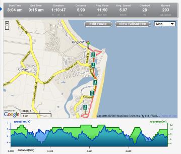
Check out this morning's walk with a friend at beautiful Kingscliff. The link will give more information, but this screenshot gives a good idea of what you'll find.
Runkeeper exports the data in a gpx file, which cannot be imported into Google Maps.
However, GPS Visualizer offers a service to convert file types. Google maps uses .kml or .kmz or geoRSS files. Google Earth uses gpx.
RK iphone app screenshot.

Runkeeper uploads a track from my iphone to the RK site (http://www.runkeeper.com) where graphs tracking my weekly and monthly are presented. Very motivating to boost the distance travelled every week. RK also shows my split times - my second kilometre is always the quickest it seems.
Check out this morning's walk with a friend at beautiful Kingscliff. The link will give more information, but this screenshot gives a good idea of what you'll find.
Runkeeper exports the data in a gpx file, which cannot be imported into Google Maps.
However, GPS Visualizer offers a service to convert file types. Google maps uses .kml or .kmz or geoRSS files. Google Earth uses gpx.
RK iphone app screenshot.
Comments